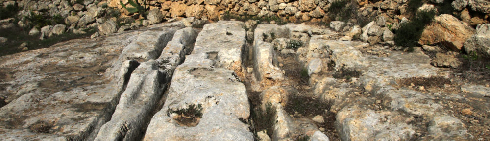
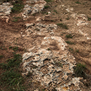
Id-Dar il-Ħamra:
One pair forming a Y-junction, another pair runs parallel to the first pair.

- Id-Dar il-Ħamra 1a: 35.922336 14.384304
- Id-Dar il-Ħamra 1b: 35.922341 14.384265
- Id-Dar il-Ħamra 2: 35.922311 14.384306
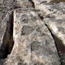
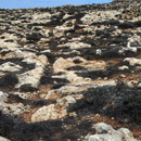
Il-Ħotba ta’ San Martin
On the ridge of the hill are fragments of partly highly eroded cart ruts.
- Il-Ħotba ta’ San Martin 1a: 35.936397 14.377468
- Il-Ħotba ta’ San Martin 1b: 35.936358 14.377403
- Il-Ħotba ta’ San Martin 1c: 35.936317 14.377318
- Il-Ħotba ta’ San Martin 2a: 35.935455 14.376502
- Il-Ħotba ta’ San Martin 2b: 35.935238 14.376205
- Il-Ħotba ta’ San Martin 2c: 35.935211 14.376171
- Il-Ħotba ta’ San Martin 2d: 35.935127 14.376063
- Il-Ħotba ta’ San Martin 2e: 35.935047 14.375975
- Il-Ħotba ta’ San Martin 2f: 35.934910 14.375798
- Il-Ħotba ta’ San Martin 3: 35.934286 14.374999
- Il-Ħotba ta’ San Martin 4: 35.933384 14.374738
Ix-Xagħra tat-Tombu
There are two pairs of cart ruts in this area. One runs from W to E, the other from NE to SE.

- Ix-Xagħra tat-Tombu 1: 35.918281 14.397056, ends at a bee-keeping site
- Ix-Xagħra tat-Tombu 2: 35.918047 14.397319, interrupted by a stone wall, at the end two stretches are intertwined
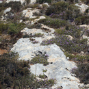
Ix-Xagħriet ta’Fraxku
29 cart ruts are located in this 250 square metres-large area east of Żebbiegħ.
Most of the ruts run in NE-SW direction.
Ix-Xagħriet ta’Fraxku 1
In the northern part of Ix-Xagħriet ta’Fraxku, all pairs run from N to S.

- Ix-Xagħriet ta’Fraxku 1a: 35.924927 14.388395
- Ix-Xagħriet ta’Fraxku 1b: 35.924884 14.388369
- Ix-Xagħriet ta’Fraxku 1c: 35.925112 14.391182
- Ix-Xagħriet ta’Fraxku 1d: 35.925197 14.392177
- Ix-Xagħriet ta’Fraxku 1e: 35.925193 14.392199
Ix-Xagħriet ta’Fraxku 2 + 3
North of Triq Il-Bidnija are four almost parallel pairs, two of them are interrupted by a stone wall. Three more parallel-running ruts are south of the road and end at a wall.

- Ix-Xagħriet ta’Fraxku 2a: 35.924512 14.390951, located in a field about 70 metres north-west of No. 2b, private property, no access
- Ix-Xagħriet ta’Fraxku 2b: 35.924164 14.391740, interrupted by a wall
- Ix-Xagħriet ta’Fraxku 2c: 35.924130 14.391757, interrupted by a wall
- Ix-Xagħriet ta’Fraxku 2d: 35.924024 14.391642
- Ix-Xagħriet ta’Fraxku 2e: 35.924006 14.391638
- Ix-Xagħriet ta’Fraxku 2f: 35.923786 14.390539, covered with demolation debris, private property, no access
- Ix-Xagħriet ta’Fraxku 2g: 35.923810 14.390464, private property, no access
- Ix-Xagħriet ta’Fraxku 3a: 35.923786 14.391842
- Ix-Xagħriet ta’Fraxku 3b: 35.923743 14.391730
- Ix-Xagħriet ta’Fraxku 3c: 35.923683 14.391763
Ix-Xagħriet ta’Fraxku 4 + 5
Five cart ruts run down a slight hill.

- Ix-Xagħriet ta’Fraxku 4: 35.922667 14.391256
- Ix-Xagħriet ta’Fraxku 5a: 35.922098 14.390530
- Ix-Xagħriet ta’Fraxku 5b: 35.922098 14.390565
- Ix-Xagħriet ta’Fraxku 5c: 35.922114 14.390616
- Ix-Xagħriet ta’Fraxku 5d: 35.922168 14.390702
Ix-Xagħriet ta’Fraxku 6 – 9
- Ix-Xagħriet ta’Fraxku 6a: 35.922112 14.389574
- Ix-Xagħriet ta’Fraxku 6b: 35.922050 14.389637
- Ix-Xagħriet ta’Fraxku 7a: 35.921450 14.389562, poorly defined
- Ix-Xagħriet ta’Fraxku 7b: 35.921436 14.389515, poorly defined
- Ix-Xagħriet ta’Fraxku 8: 35.921311 14.389300
- Ix-Xagħriet ta’Fraxku 9a: 35.921686 14.389044
- Ix-Xagħriet ta’Fraxku 9b: 35.921678 14.389010
- Ix-Xagħriet ta’Fraxku 9c: 35.921156 14.389122, probably connected with No. 9b
Ix-Xagħriet ta’Fraxku 10 + 11: Two pairs running parallel to each other from E to W.

- Ix-Xagħriet ta’Fraxku 10: 35.923122 14.387918
- Ix-Xagħriet ta’Fraxku 11: 35.923088 14.387918
L’Imselliet
private property, no access
Mġarr
There is a limited area prepared for the protection of cart ruts north-west of the roundabout between Mġarr and Żebbiegħ. Seven pairs of cart ruts can be seen. After a cleaning of the area in May 2019, five more cart ruts have become visible.
- Mġarr 1: 35.919343 14.372874
- Mġarr 2a: 35.919434 14.372856
- Mġarr 2b: 35.919306 14.372724
- Mġarr 3a: 35.919363 14.372857
- Mġarr 3b: 35.919248 14.372894, branches off No. 1
- Mġarr 4: 35.919380 14.373005
- Mġarr 5: 35.919340 14.373018
- Mġarr 6: 35.919256 14.373004
- Mġarr 7a: 35.919096 14.372762
- Mġarr 7b: 35.919203 14.372976, intersects No. 3a
- Mġarr 8: 35.919178 14.372991, intersects No. 3a
- Mġarr 9: 35.919071 14.372892
- Mġarr 10: 35.920481 14.371010, 200 meters northwest of the cart ruts group Mġarr 1 – 9 one nearly four meter long cart ruts fragment can be seen. photos ©Rosita Camilleri
Qala Pellegrin
On the cliff’s edge, north-west of the plateau Qala Pellegrin, is a 67-metre-long pair of cart ruts.
- Qala Pellegrin 1: 35.915428 14.337094
- Qala Pellegrin 2: not yet found
Ras il-Wied
Two stretches of cart ruts along the south side of the road.
- Ras il-Wied 1: 35.929925 14.384593, mostly destroyed by construction work, only one rut visible
- Ras il-Wied 2: 35.929573 14.383549
Ta’Garibaldi: 5.9245080 14.360392
One partly eroded pair of cart ruts running from N to S.

Ta’Lippija
There are six mostly eroded cart ruts in the Il-Lippija area.Two longer stretches have short branches.
- Ta’Lippija 1: 35.923822 14.356820
- Ta’Lippija 2a: 35.923213 14.352153
- Ta’Lippija 2b: 35.923202 14.352143
- Ta’Lippija 3: 35.923201 14.351965
- Ta’Lippija 3b: 35.922955 14.352176
- Ta’Lippija 4: 35.922779 14.352176
- Ta’Lippija 5: 35.924318 14.349453
- Ta’Lippija 6: 35.923049 14.352598
Ta’Mrejnu
There are nine cart ruts running in NW-SE direction west of Triq Sir Harry Luke. There is another pair and an old quarry east of the road. North of Triq Għajn Tuffieħa runs a slightly curved pair of cart ruts from W to E.
- Ta’Mrejnu 1a: 35.926975 14.367839
- Ta’Mrejnu 1b: 35.926728 14.368151
- Ta’Mrejnu 1c: 35.926649 14.368257
- Ta’Mrejnu 1d: 35.926696 14.368108
- Ta’Mrejnu 1e: 35.926676 14.368071
- Ta’Mrejnu 1f: 35.926649 14.368038
- Ta’Mrejnu 1fg 35.926607 14.368053
- Ta’Mrejnu 1h: 35.926550 14.368322, slightly curved
- Ta’Mrejnu 1i: 35.926447 14.368692, extremely eroded
- Ta’Mrejnu 2: 35.929138 14.367522
- Ta’Mrejnu 3a: 35.929179 14.369244, not traced, no access
- Ta’Mrejnu 3b: 35.929183 14.369258, not traced, no access
Tal-Faċċol
A large group of cart ruts, running parallel from NE to SW, to disappear after about 25 metres under vegetation and developed farmland. After about 45 metres they are visible again.
Since mid-2016, cart ruts No. 1 to No. 9 are completely destroyed.
- Tal-Faċċol 1: 35.924322 14.381234
- Tal-Faċċol 2: 35.924296 14.381266
- Tal-Faċċol 3: 35.924286 14.381279
- Tal-Faċċol 4: 35.924295 14.381309, image from April 2016
- Tal-Faċċol 5: 35.924281 14.381316, image from April 2016
- Tal-Faċċol 6: 35.924276 14.381336
- Tal-Faċċol 7: 35.924256 14.381350
- Tal-Faċċol 8: 35.924247 14.381394
- Tal-Faċċol 9: 35.924346 14.381504
- Tal-Faċċol 10: 35.924311 14.381535, from the original 28 meters, only 8 meters left
- Tal-Faċċol 11: 35.923862 14.380774
- Tal-Faċċol 12: 35.923776 14.380728
- Tal-Faċċol 13: 35.923799 14.380820
- Tal-Faċċol 14: 35.923913 14.380928
- Tal-Faċċol 15: 35.923873 14.380927
- Tal-Faċċol 16: 35.923842 14.380932
- Tal-Faċċol 17: 35.923888 14.380993
- Tal-Faċċol 18: 35.923494 14.380518
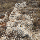
Tal-Ħżejjen
Some probably modern sets have been visible along Triq Tal-Ħżejjen. South of Triq Tal-Ħżejjen three pairs of cart ruts run in a NE-SW direction.

- Tal-Ħżejjen 1: 35.919791 14.384265, probably modern, since August 2017 concreted
- Tal-Ħżejjen 2: 35.919318 14.386656
- Tal-Ħżejjen 3: 35.919292 14.386700
- Tal-Ħżejjen 4: 35.919070 14.386380
Tal-Palma
200 metres north of Triq Għajn Tuffieħa are five pairs of cart ruts. Two run from N to S and three from W to E.
- Tal-Palma 1: 35.931092 14.364342
- Tal-Palma 2: 35.930753 14.364306
- Tal-Palma 3: 35.930132 14.363386
- Tal-Palma 4: 35.930211 14.361850
- Tal-Palma 5: 35.929743 14.360961
Żebbiegħ 1 – 8
Eight pairs of cart ruts, two of them are heavily demolished by trucks and heavy machinery.
- Żebbiegħ 1: 35.922996 14.379409, one short pair in disturbed garrigue land
- Żebbiegħ 2a: 35.922435 14.381962, demolished by parked trucks
- Żebbiegħ 2b: 35.922138 14.382008, parked trucks and heavy machinery
- Żebbiegħ 3a: 35.922425 14.382023, demolished by parked trucks
- Żebbiegħ 3b: 35.922143 14.382075, parked trucks and heavy machinery
- Żebbiegħ 4: 35.922003 14.381699, shallow pair
- Żebbiegħ 5: 35.921977 14.381692, poorly defined
- Żebbiegħ 6: 35.921090 14.381800, running south of Triq il-Bidnija
- Żebbiegħ 7: Not yet clarified
- Żebbiegħ 8: 35.919240 14.378527, one pair of cart ruts became evident when the scrubland was cleared for development.
Żebbiegħ 9 – 12
Four pairs of cart ruts became evident in 2019 after a farmhouse was demolished and scrubland was cleared for development.
Information and photos ©Rosita Camilleri
- Żebbiegħ 9: 35.920223 14.381658
- Żebbiegħ 10: 35.920266 14.381682, almost 60 m long
- Żebbiegħ 11: 35.920178 14.382003, previously possibly connected to No. 6
- Żebbiegħ 12: 35.920175 14.382039, previously possibly connected to No. 6
© Monika I. Trinkler