Ċirkewwa: 35.984006 14.334589
One pair runs along the cliffs to Paradise Bay and ends at the edge of the cliff that has collapsed.
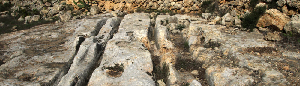
Għajn Żnuber
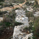
North-west of Manikata, near the cliffs of Majjistral Park, are three short remnants of cart ruts.

- Għajn Żnuber 1: 35.946858 14.340131
- Għajn Żnuber 2: 35.946394 14.340411, poorly defined
- Għajn Żnuber 3: 35.946042 14.340372, poorly defined
Id-Daħar
Several poorly definable pairs run along Triq tad-Daħar in N-S direction.
- Id-Daħar 1: 35.974072 14.335561, covered with concrete
- Id-Daħar 2: 35.972544 14.335261, poorly defined
- Id-Daħar 3: 35.973131 14.334336
- Id-Daħar 4: 35.973569 14.332283, poorly defined
- Id-Daħar 5: 35.972925 14.329119, poorly defined
Il-Bajja tal-Mellieħa: 35.968103 14.351842
One pair, interrupted several times, leads along the coast line. At the NW-end it forks into two pairs.

Il-Bisqra
A large network of cart ruts is visible west of the Danish Village. Group 1 is pretty much eroded.

- Il-Bisqra 1a: 35.968287 14.345959
- Il-Bisqra 1b: 35.968268 14.345831
- Il-Bisqra 1c: 35.968227 14.345794
- Il-Bisqra 1d: 35.968209 14.345779
- Il-Bisqra 1e: 35.968169 14.345815
- Il-Bisqra 1f: 35.968148 14.345884
- Il-Bisqra 1g: 35.968132 14.345832
- Il-Bisqra 1h: 35.968106 14.345827
- Il-Bisqra 2: 35.967878 14.345458
- Il-Bisqra 3: 35.967356 14.345200
Il-Gudja: 35.963454 14.340855
One pair of cart ruts runs down the hill north of Popeye Village.
Il-Hewwiexa
North of Tal-Braġġ are two equally long cart ruts running in W-E direction.

- Il-Hewwiexa 1: 35.956168 14.376858
- Il-Hewwiexa 2: 35.956088 14.376884
Il-Kamp tal-Mellieħa: 35.968467 14.348767
One short cart rut between Għadira Natural Reserve and the Danish Village can be seen.

Il-Minżel: 35.940050 14.338361
Only a short piece of a formerly long stretch is still visible.
Il-Mogħxa ta’Għajn Tuffieħa
To the west of Manikata, there are three tracks. No. 1 and No. 2 may have been connected.

- Il-Mogħxa ta’Għajn Tuffieħa 1: 35.938092 14.343111
- Il-Mogħxa ta’Għajn Tuffieħa 2a: 35.938157 14.342640
- Il-Mogħxa ta’Għajn Tuffieħa 2a: 35.938071 14.343826, forks out on the western end 2a
It-Torri ta› Għajn Żnuber
Four poorly defined stretches running in a NE to SW direction, five stretches running in a NW to SE direction.

- It-Torri ta› Għajn Żnuber 1: 35.949919 14.343435
- It-Torri ta› Għajn Żnuber 2: 35.949903 14.343110
- It-Torri ta› Għajn Żnuber 3: 35.949655 14.342391
- It-Torri ta› Għajn Żnuber 4: 35.949846 14.342191
- It-Torri ta› Għajn Żnuber 5: 35.949901 14.342001
- It-Torri ta› Għajn Żnuber 6: 35.950010 14.341746
- It-Torri ta› Għajn Żnuber 7: 35.949850 14.341956
- It-Torri ta› Għajn Żnuber 8: 35.949864 14.341856
- It-Torri ta› Għajn Żnuber 9: 35.949865 14.341792
Ix-Xagħra: 35.982421 14.334175
One barely visible cart rut above Paradise Bay leads to the edge of the cliff, which is probably collapsed.

Ix-Xagħra il-Ħamra
Three short stretches running in a NS direction to the west of Manikata.

- Ix-Xagħra il-Ħamra 1: 35.939672 14.347956, poorly defined
- Ix-Xagħra il-Ħamra 2: 35.941292 14.347097
- Ix-Xagħra il-Ħamra 3: 35.941784 14.347129
Ix-Xagħra tad-Dar il-Bajda: 35.945211 14.371769
A very short stretch of cart ruts running near the road in a W-E direction.
Ix-Xagħra tal-Għansar: 35.946978 14.370258
Parallel to the road runs a longer pair of cart ruts.
Ix-Xagħra tal-Qortin
Five mostly eroded stretches of cart ruts running from N to S.

- Ix-Xagħra tal-Qortin 1: 35.938878 14.339472, poorly defined
- Ix-Xagħra tal-Qortin 2: 35.940359 14.339944, poorly defined
- Ix-Xagħra tal-Qortin 3: 35.940478 14.340200, poorly defined
- Ix-Xagħra tal-Qortin 4: 35.941453 14.340222, poorly defined
- Ix-Xagħra tal-Qortin 5: 35.942153 14.339525, poorly defined
L-Imġiebaħ
In Il-Qortin ta› Ghajn Żejtuna between Mellieħa east and Wied tal-Imġiebaħ are nine cart ruts.
No. 2, 3 and 4 were once probably one stretch.
- L-Imġiebaħ 1: 35.959306 14.373787
- L-Imġiebaħ 2: 35.961997 14.374000
- L-Imġiebaħ 3: 35.962464 14.374267
- L-Imġiebaħ 4: 35.962997 14.374536
- L-Imġiebaħ 5: 35.964486 14.375475
- L-Imġiebaħ 6: 35.962497 14.377402
- L-Imġiebaħ 7: 35.962189 14.375767, partly eroded and overgrown
- L-Imġiebaħ 8: 35.959830 14.377154
- L-Imġiebaħ 9: 35.959739 14.377081
Manikata north
Five pairs of cart ruts can be found north of Manikata.
- Manikata north 1: 35.941610 14.351992
- Manikata north 2: 35.941553 14.352244
- Manikata north 3: 35.941796 14.353928
- Manikata north 4: 35.942536 14.355503, obliterated by tomb shaft
- Manikata north 5: 35.943219 14.355484, poorly defined
Manikata north-east
One 330-metre-long stretch runs from E to W. At the western end there is a group consisting of five cart ruts.

- Manikata north-east 1: 35.941757 14.357851
- Manikata north-east 2: 35.941444 14.360616
- Manikata north-east 3: 35.941907 14.360908
- Manikata north-east 4: 35.941565 14.360771
- Manikata north-east 5: 35.941568 14.360950
- Manikata north-east 6: 35.941451 14.361119, mostly eroded
Qasam Barrani
Near Mellieħa bypass four pairs of cart ruts lead down the slope.1a and 1b run together at the southern end.

- Qasam Barrani 1a: 35.961487 14.350991
- Qasam Barrani 1b: 35.961500 14.350968
- Qasam Barrani 2: 35.961493 14.350906
- Qasam Barrani 3: 35.961512 14.350830
- Qasam Barrani 4: 35.961375 14.350703
San Niklaw
Close to Mellieħa bypass are six pairs of cart ruts, two pairs intersect.

- San Niklaw 1: 35.959812 14.350609
- San Niklaw 2: 35.959548 14.350204, intersect with No. 1
- San Niklaw 3: 35.959316 14.349935
- San Niklaw 4: 35.959445 14.349732
- San Niklaw 5: 35.959200 14.350527
- San Niklaw 6: 35.959214 14.350466
Selmun
There are three pairs of cart ruts in the area of Selmun, at the southern end of Wied tal-Imġiebaħ.
- Selmun 1: 35.958644 14.379156
- Selmun 2: 35.958592 14.378295
- Selmun 3: 35.959346 14.377892, partly covered with soil and vegetation
Tal-Braġġ
Five pairs are visible close to a small regular shallow quarry and Il-Hewwiexa tombs.

- Tal-Braġġ 1: 35.955354 14.375777
- Tal-Braġġ 2: 35.955233 14.375831
- Tal-Braġġ 3: 35.955225 14.376394
- Tal-Braġġ 4: 35.955614 14.376275
- Tal-Braġġ 5: 35.955609 14.376205
Tat-Tomna
On the northern flank of Mellieħa Ridge, only heavily eroded fragments are found
- Tat-Tomna 1: 35.951554 14.349384, interrupted by a path
- Tat-Tomna 1a: 35.950972 14.348094, fork at the south-east end, poorly visible
- Tat-Tomna 2: 35.951860 14.349861
- Tat-Tomna 3: 35.952151 14.351669, only one furrow visible
- Tat-Tomna 4: 35.954621 14.352566
Tax-Xemgħa
On the slope from the Medieval Road (incorrectly referred to as Roman Road) to Mistra Valley 15 pairs run from W to E. Some of them running parallel to the others. On the path down, more cart ruts fragments have become visible after heavy rains. No. 1 is on the opposite slope.
- Tax-Xemgħa 1: 35.951922 14.373361, partly covered with soil and debris
- Tax-Xemgħa 2: 35.951196 14.380875
- Tax-Xemgħa 3: 35.951159 14.380803
- Tax-Xemgħa 4: 35.951167 14.380301
- Tax-Xemgħa 5: 35.951106 14.380335
- Tax-Xemgħa 6: 35.950907 14.379558
- Tax-Xemgħa 7: 35.950867 14.379589
- Tax-Xemgħa 8: 35.950816 14.379573
- Tax-Xemgħa 9: 35.950842 14.379798
- Tax-Xemgħa 10: 35.950752 14.379213
- Tax-Xemgħa 11: 35.950715 14.378987
- Tax-Xemgħa 12: 35.950684 14.378985
- Tax-Xemgħa 13: 35.950650 14.378977
- Tax-Xemgħa 14: 35.950019 14.378390
- Tax-Xemgħa 15: 35.950021 14.378258
- Tax-Xemgħa 16: 35.950019 14.378057
- Tax-Xemgħa 17: 35.950063 14.377798
- Tax-Xemgħa 18: 35.950024 14.377410
- Tax-Xemgħa 19: 35.949969 14.377371, covered with vegetation
- Tax-Xemgħa 20: 35.949877 14.377348
Wied ta’Rduna
On the northern flank of Mellieħa Ridge, only heavily eroded fragments are visible.
- Wied ta’Rduna 1: 35.954516 14.345172, not yet found, eroded?
- Wied ta’Rduna 2: 35.952470 14.345971
- Wied ta’Rduna 3: 35.952615 14.344909
- Wied ta’Rduna 4: 35.951195 14.345900
- Wied ta’Rduna 5: 35.951214 14.345818
- Wied ta’Rduna 6: 35.951191 14.345728
© Monika I. Trinkler